Greensboro's growth from a late-1800s railroad hub into a modern Triad city has left a patchwork of cut-and-fill terrain that makes excavation work unpredictable. The Cecil Street corridor and areas near North Elm sit on residual soils from weathered Carolina slate belt rock — competent in places, but prone to rapid strength loss when moisture rises. Our geotechnical excavation monitoring program tracks exactly that transition. We deploy vibrating wire piezometers, in-place inclinometers, and optical survey targets to give contractors continuous data on wall deflection, groundwater migration, and surface settlement. For deep utility cuts along Wendover Avenue, where the water table sits within 12 feet of grade in wet seasons, we often pair automated total stations with manual heave stakes to cross-check readings. The result is a defensible record that satisfies OSHA Subpart P requirements and lets superintendents adjust shoring or dewatering before a condition becomes a citation — or worse, a collapse. In a city where Triassic basin sediments meet saprolite at unpredictable depths, deep excavation monitoring forms the backbone of any safe urban dig.
You can't manage what you don't measure. In Greensboro's mixed saprolite and basin fill, a reliable inclinometer baseline taken before excavation is the difference between a controlled dig and a surprise ground loss.
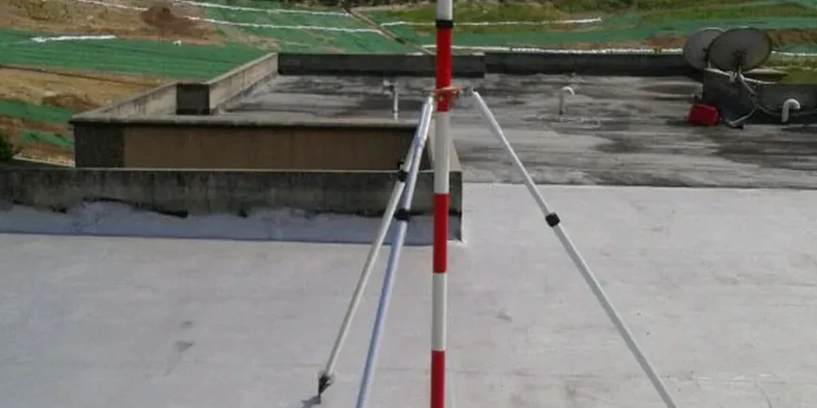
Our approach and scope
Local context
The soil profile shifts dramatically between the Wendover Avenue commercial strip and the older neighborhoods around Fisher Park. Near Wendover, deep cuts often encounter saprolite that holds a face well until a summer thunderstorm saturates the upper 6 feet; we have watched inclinometer deflection rates triple in 24 hours under that scenario. Fisher Park, by contrast, sits on shallow residual soils over fractured bedrock: the risk there is not global slope failure but differential heave when dewatering lowers the water table and desiccated clay rebounds under reduced effective stress. Contractors who treat both sites the same end up with cracked sidewalks and utility misalignments. Our monitoring plan tackles this by zoning the excavation into instrument clusters — tighter spacing where the geologic contact is mapped within the dig footprint, and real-time thresholds that tighten automatically when the National Weather Service issues a flash flood watch for Guilford County.
Regulatory framework
ASCE 7-22 (Minimum Design Loads and Associated Criteria for Buildings and Other Structures), IBC 2021 Chapter 33 (Safeguards During Construction), ASTM D7299 (Standard Practice for Verifying Performance of Inclinometers), ASTM D5092 (Installation of Groundwater Monitoring Wells in Aquifers), OSHA 29 CFR 1926 Subpart P (Excavations)
Related services
Instrumentation Installation and Baseline Survey
We install inclinometer casing, vibrating wire piezometers, and settlement points before the shoring crew mobilizes. A complete baseline survey — inclinometer groove alignment, initial water levels, and prism coordinates — is captured and signed off by the project geotechnical engineer.
Continuous Monitoring and Threshold Management
Readings are collected on a schedule tied to excavation progress and weather. Data flows into a password-protected dashboard with automated alerts; the engineer-of-record receives a weekly memo comparing measured deformations against the geotechnical baseline report predictions, with clear go/no-go criteria for continued digging.
Typical parameters
FAQ
What does geotechnical excavation monitoring typically cost for a commercial project in Greensboro?
Budget between US$780 and US$2,400 depending on instrument count and monitoring duration. A small utility trench with survey prisms and one piezometer sits at the lower end, while a multi-level parking garage excavation with automated inclinometers, multiple piezometers, and daily total station runs falls in the upper range.
How often do you take readings during active excavation?
Inclinometers and survey prisms are read at least once per 24 hours during active digging, and more frequently — every 4 to 6 hours — when the excavation is deeper than 15 feet or after heavy rainfall. Piezometers are logged continuously and polled every 30 minutes.
What triggers an alert, and who receives it?
We set thresholds at 80% of the allowable deflection or head differential defined in the geotechnical baseline report. When an instrument crosses that line, an SMS and email go to the superintendent, the project geotechnical engineer, and our on-call engineer simultaneously so the shoring or dewatering plan can be adjusted before the next shift.
Can you monitor an existing excavation that is already underway?
Yes, but we lose the pre-excavation baseline. We install instruments at the earliest possible stage and establish a 'best available' reference from the first reading set, then track deformation trends from that point forward. The interpretation memo will clearly note that the baseline is post-excavation and will rely on comparative trend analysis rather than absolute displacement criteria.